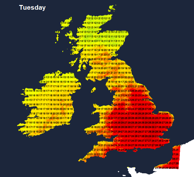
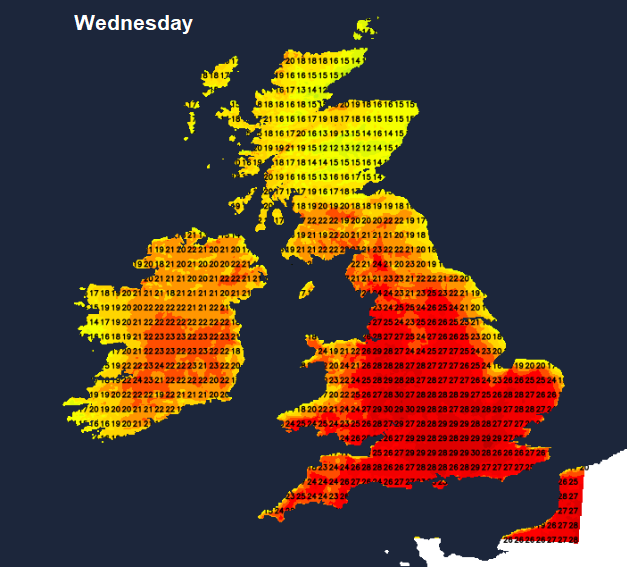
Temperatures could reach 29C by Tuesday, perhaps 30C on Wednesday in London. Birmingham should see 25 or 26C in the next two days, Manchester similar but then easing off to 21C for Thursday onwards. Glasgow will also feel fresher by Thursday after seeing temperatures of 23 or 24C.
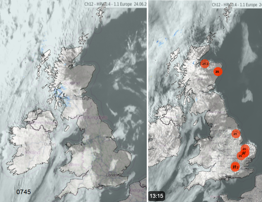
Hull reached 25.7C on Sunday. Suffolk, Derbyshire, Herefordshire and north London also passed 25C. Heathrow reached 26.1C on Friday 21st June. Summer is finally with us. For some, that means a lot of sneezing with itchy eyes and nose as we are now in peak pollen season with very high levels of grass and nettle pollen. UV levels are also high.
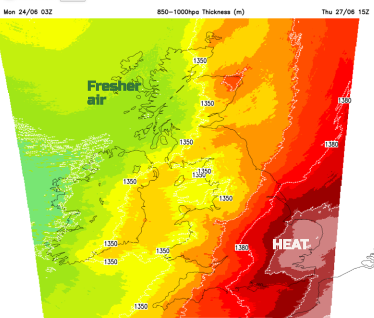
Pulses of hot air will surge up through Europe. In Spain, Madrid should reach 35C on Tuesday. Paris 32C by Wednesday with Scandinavia seeing warm air too, Stockholm is forecast to reach 28C in the next few days. All of the UK will experience this warm air but England and Wales will hold onto the heat as Northern Ireland and Scotland see fresher Atlantic influences edge in.
High pressure has been close to the UK on Monday but will slide eastwards towards the Baltic Sea. If it had remained nearby, the forecast would have been simpler; fine and hot. The tricky part under high pressure is low cloud off the sea, the North Sea haar or fog around Cornish coasts. However, Atlantic fronts will manage to creep in from the west as the high pressure isn’t sticking around to be a steady buffer. A significant low pressure is forecast to move between Scotland and Iceland on Thursday. Any extra cloud inhibits the highest temperatures, whether that is sea fret or frontal cloud. The low will introduce showery rain from the northwest by Thursday but that will struggle to make progress southwards. The heat could remain in England for a few more days. Friday night looks potentially cool with temperatures dropping down into single figures as the school summer holidays begin in Scotland and Northern Ireland.

Monday and Tuesday
There was early low cloud for western areas which has taken it’s time to disappear. Other spots with blue skies and sunshine are seeing temperatures leaping up, past 20C in eastern Britain before 11am. By this afternoon, many parts will be fine and dry, brighter as the cloud thins and breaks. There will be a fresh southerly wind for the Western Isles and a cold front will bring cloud and light rain into the far NW during Monday night. For the start of Tuesday, there will be grey skies and damp conditions for the NW Highlands and County Down. This front is important on Tuesday as there will be a difference with the air masses NW/SE and it brings the chance of a few showers over (mainly the higher ground of) northern Britain.

For England and inland Wales, Tuesday will be hot with hardly any breeze. Temperatures will widely be in the mid to high twenties Celsius. Central and southern Scotland, the far north of England and western England should all reach the high teens and low 20sC. Thicker frontal cloud remains for Northern Ireland and northern mainland Scotland. Later on Tuesday, there could be heavier rain for Grampian.

The heat will be focused over the southern half of Britain on Wednesday but Northern Ireland should have a sunnier day with temperatures into the low 20sC. That front will still be a feature, with more cloud over northern Britain and low cloud off the North Sea for eastern Scotland in a light northeasterly breeze. The flow off the sea will also restrict temperatures for east coast England but 18C won’t feel too bad. Inland it will be hot with a very warm night for England. A ‘Tropical Night’ is when the UK temperature doesn’t fall below 20C, the daily minimum temperature exceeds 20°C.

Next, we await the Atlantic low pressure. There are signs that showery rain and cloud could reach western Britain, with more unsettled weather for Northern Ireland and Scotland, particularly in the west. The UKV Model shows London and the Home Counties holding onto the heat through Thursday with plenty of sunshine but an overall trend of the fresher north Atlantic air taking hold across the UK for the weekend. The heat will continue for the western and central Mediterranean, into central Europe then surging towards Poland. Higher temperatures and again the risk of thunderstorms for the Euro 2024 games in Germany and the fans whose teams continue.

