

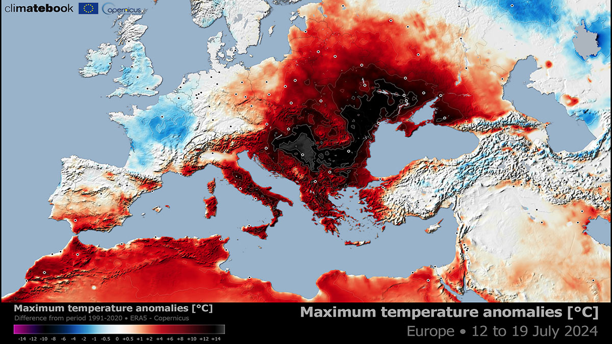
Parts of Europe have been under a prolonged heatwave since early July, and the heat is forecast to extend for another two weeks. Historic heatwaves with temperatures exceeding the 40 °C threshold daily are the most intense across the Balkan peninsula and Eastern Europe. Mediterranean region seas are also becoming hot, reaching 30 °C in places.
According to the forecasts of the global weather models, temperatures throughout July will remain much above average across Southern and Eastern Europe. The most abnormal temperatures are again forecast for the Balkan peninsula, with record-shattering values this week.
A temporal dynamic weather pattern started this July after the first significant summer season 2024 heatwave in late June. But soon after, the general pattern shifted into a stable one, inducing a prolonged heatwave across a portion of the continent. Temperatures are on the increase and are forecast to climb further this week.
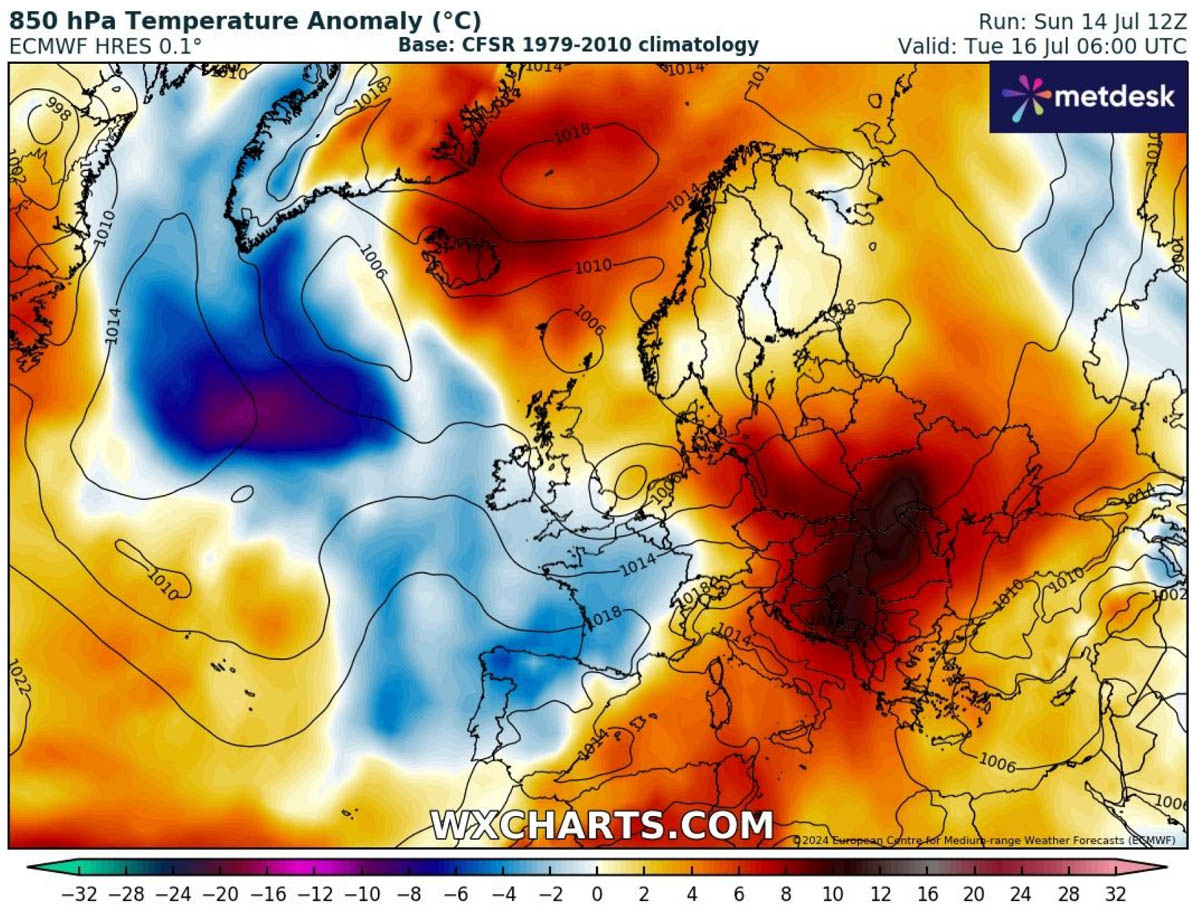
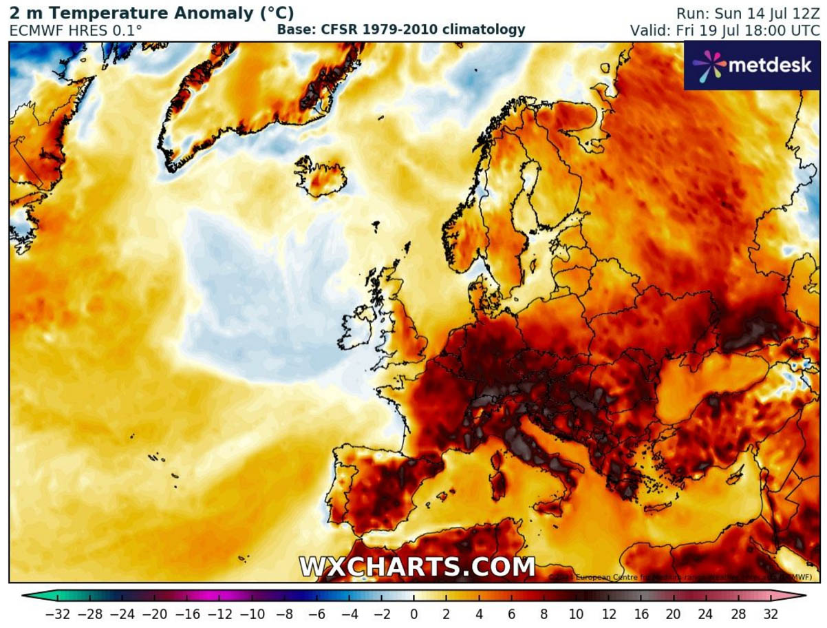
The image below shows the maximum temperature on Sunday, July 14th. It indicates that excessive heat is underway from North Africa across the Mediterranean region into the Balkan peninsula and Eastern Europe.
Temperatures have reached the upper 30s in many areas, with above +40 °C recorded in Romania, Serbia, Albania, Bulgaria, Bosnia, North Macedonia, and Greece in recent days.
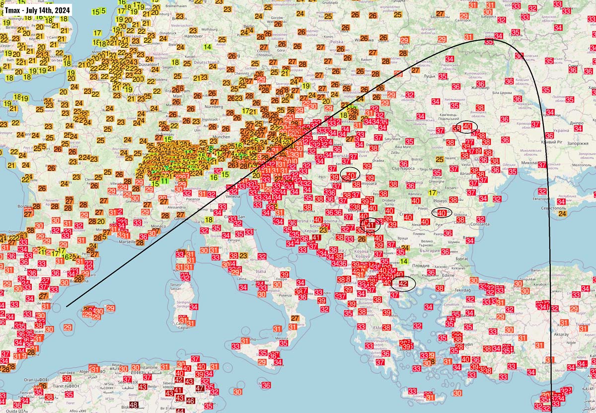
It was historically hot in Serbia, central Balkans. The weather station in Vršac (northeast Serbia) had an astonishing minimum temperature of +30.6 °C on Saturday and +31.2 °C on Sunday! This is most likely the highest minimum temperature ever recorded in Serbia.
Serbia’s capital, Belgrade, reported a minimum temperature of +27.3 °C on Saturday and +27.5 °C on Sunday. These values are also very close to record highs for the lowest daily temperatures.
High night temperatures were also reported in surrounding countries, such as Croatia, Bosnia, Romania, and North Macedonia. Greece has also noted that the minimum temperature does not fall below 30 °C at some stations over the weekend.
This ongoing weather pattern will continue across Europe until early next week, with the blocking high further strengthening from the Mediterranean region into Eastern Europe, thanks to a heat dome establishing aloft.
July is known as the hottest month of the summer, but the temperatures these days and in the coming 7-10 days will be much higher than the average. Around ten °C too warm daily averages in many regions.
What is a Heat dome, and why does it bring long-lasting heatwaves and excessive temperatures?
The Heat Dome is the primary background feature that causes major heat waves globally every year. During the summer of 2023, there were extreme heatwave events, which continued into September and October. There have been thousands of record-breaking stations, and the temperature anomalies have often been off the charts.
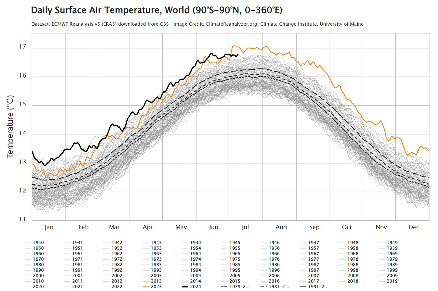
Global temperatures from January through June this year have exceeded the long-term averages. This anomaly has been so significant over the last 12 months that the chart provided by CopernicusEU undoubtedly speaks for itself.
The Heat Dome is that feature that leads to these extreme heat events. Usually, the heat dome is the main and the most dominant feature of summer weather patterns in Europe and North America. Still, it can also occur in autumn, as we are experiencing last year.
We hear the term heat dome when extremely high and anomalous temperatures develop. Here is how it works and why it is essential to understand it from a larger scale. The upper-level ridge pattern, or warm air mass in the higher altitudes, is known as the Upper High (we often use the term blocking High). It usually forms the heat dome.
So, this specific term is used when a broad area of high-pressure parks over a large portion of the continent. If the event is exceptionally stable and extreme, it usually stays there for several days or weeks.
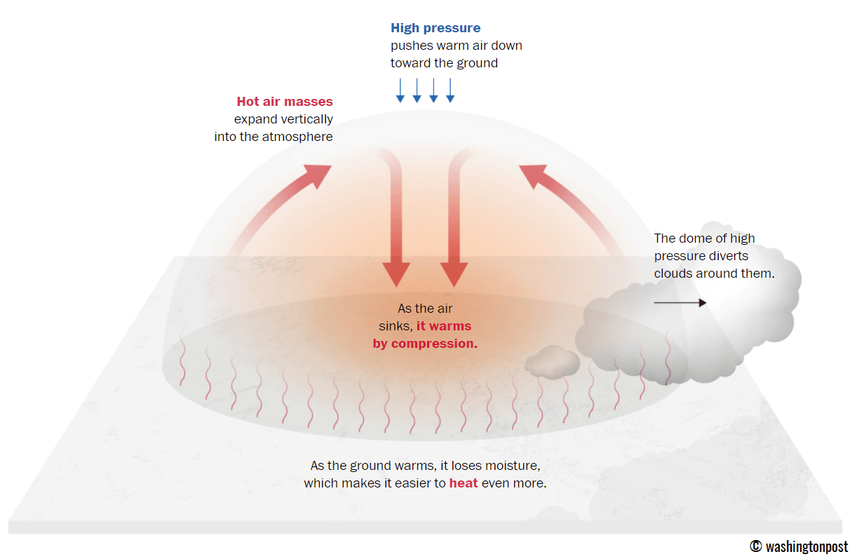
The heat dome works like a lid on a pot. The extensive dome of heat traps a significantly warmer air mass at all levels underneath, sinking its layers toward the ground. Therefore, the air mass becomes dry and significantly warms as it reaches the lowest elevations.
A heat wave associated with a heat dome creates fair, stable weather and an often arid air mass with minimal chances for precipitation or even clouds. This happens due to the sinking air parcels in the center of the heat dome, resulting in rising temperatures. Sometimes, we see the weather pattern developing a so-called Omega blocking High.
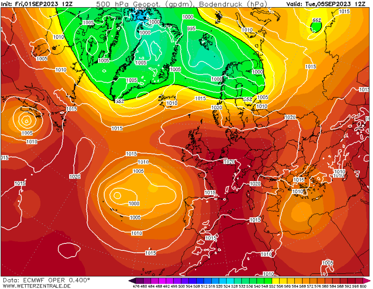
The example below shows this kind of omega-blocking pattern over Europe from early September last year. The pattern engulfed a large part of the continent, with a central heat dome and a low-pressure system on each side. One low was over the southern Mediterranean, and the other over the Azores.
Especially during dry summer, drier and warmer weather produces a significantly enhanced wildfire threat due to developing drought. Or additionally worsening the ongoing, pre-existing, arid conditions. Such examples were wildfires in the Pacific Northwest and other parts of western North America in recent years or in Europe (Greece, Portugal, etc.) during last year’s summer season.
A heat dome is often also to blame for deadly heatwaves worldwide, as the scorching and excessive heat usually lasts for a very long period. Such heat dome events brought record temperatures in many countries worldwide in the summer of 2023, extending into the fall seasons.
The daily average, minimum, and maximum temperatures under the heat dome are typically significantly above average. When the heat dome is solid, it challenges existing historical records. This becomes particularly striking when this feature develops during early summer or autumn.
Extensive blocking high will dominate Europe this week. Heatwave intensifies further beneath
This week, the high-pressure system will re-build from the south towards the north and east Europe, thanks to a strengthening heat dome and blocking high aloft. This will allow the heatwave to even further intensify over the Balkan peninsula and Eastern Europe.
The upper-level ridge is forecast to be the strongest towards the weekend, pushing temperatures in the lowest levels back towards the mid-40s in some areas across the central Balkans and southern Iberia.
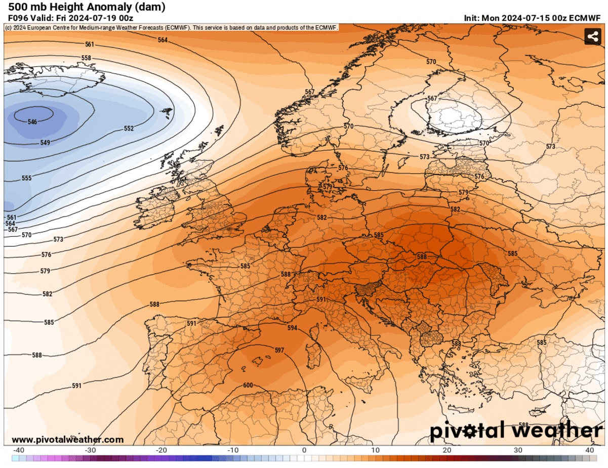
Through mid-week, the highest temperature anomaly is again expected across the south-central Balkans and Eastern Europe. Temperatures will be around 8-10 °C above the average for mid-July.
The re-strengthening heatwave will maintain and even further intensify the lowlands temperatures across the Balkan peninsula and further east across Ukraine, Belarus, and western Russia.
The following chart indicates the 2 m temperature anomaly on Tuesday this week, with a striking abundant heat and more than 15 °C warmer temperatures for the countries underneath the heat dome.

From Thursday through Saturday, the hottest air mass will gradually take a break over the Balkans but will remain very high. It will be a few degrees lower than through the early and mid-week days.
However, with the expansion of the blocking ridge aloft also further north and west towards the weekend, the heat will progress towards Germany and France again. But it will not be scorching, but somewhat back to near average temperatures given the relatively colder period on the West since early July.
The general temperature picture hints at the summer heat continuing to dominate most of Europe later this week.
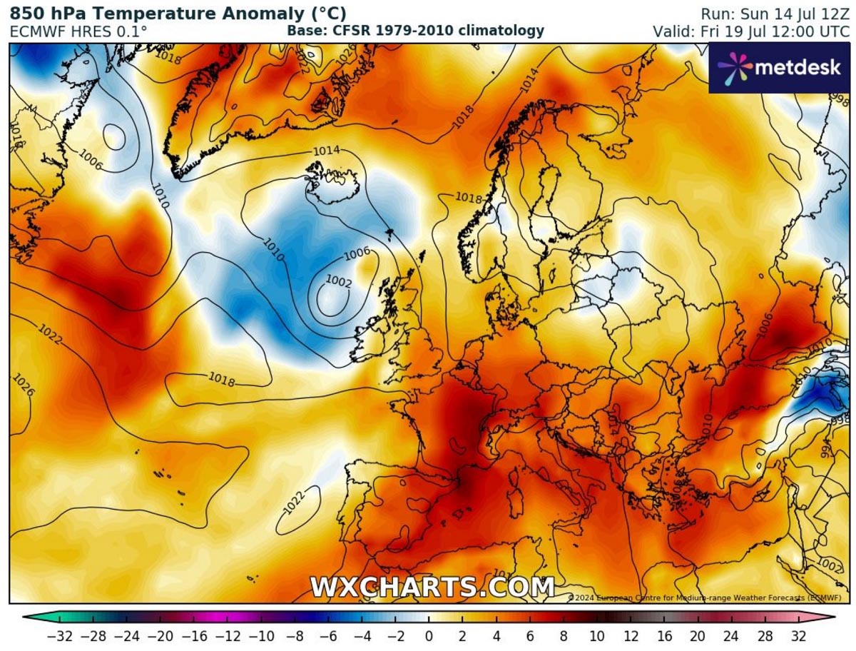
The 2m temperature anomaly chart below indicates warmer temperatures on Friday when heat will strengthen across central and western Europe. Meanwhile, it will still be extreme on the Balkan peninsula, although a tad lower than early this week.
Thursday through Saturday, the hottest air mass will be across the southern half of Europe, from Spain and Portugal across Italy to the Balkans and the north of the Alps across parts of Germany, Czechia, and Slovakia.
The afternoon temperatures will be much above the average for mid-July, locally even more than 12 °C above. Hinting temperatures will quickly climb into the low to mid-30s and above the +40 °C threshold further south.
Below is a video animation of the re-developing heatwave and its progress across portions of Europe this week. Throughout the second half of the week, we can see the development of a dominating blocking pattern with significantly warmer air mass underneath, spreading north.
The overall weather model consensus also suggests that chances for rain and thunderstorms will be lower over the coming 5-10 days due to more stable and drier air mass associated with the heat dome aloft.
Peak temperatures will persist from the upper 30s to the low 40s °C in many areas, which could set new records
With the upper High gradually expanding and strengthening from the Mediterranean into central and Eastern Europe this week, temperatures will warm up further from Portugal and Spain across Italy, central Europe, the Balkan peninsula, Hungary, Czechia, Slovakia, and further east into Belarus and Ukraine.
Mediterranean and Balkan peninsula
From Tuesday through Friday, peak afternoon temperatures are forecast to reach the low to mid-40s across central and eastern Balkans, including central and southern Italy.
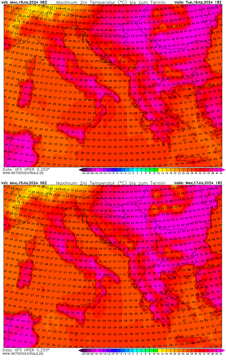
The highest temperatures on Tuesday and Wednesday could challenge some maximum temperature records for parts of Serbia and Romania since high-resolution models peak those into the 43-45 °C range.
It will also be hot in Albania, North Macedonia, and Greece in the southern Balkans. This prolonged scorching heat will worsen the ongoing drought conditions in the south and could trigger more wildfires.
Eastern Europe
The heatwave will also re-intensify in Eastern Europe through Wednesday and Thursday. Temperatures will be back into the low 40s across Ukraine, Moldova, and potentially also southwestern Russia.
Especially Thursday brings excessive heat with peak temperatures around 42-43 °C across southern Ukraine. Temperatures will be lower further north towards Belarus and should remain near the low 30s °C.
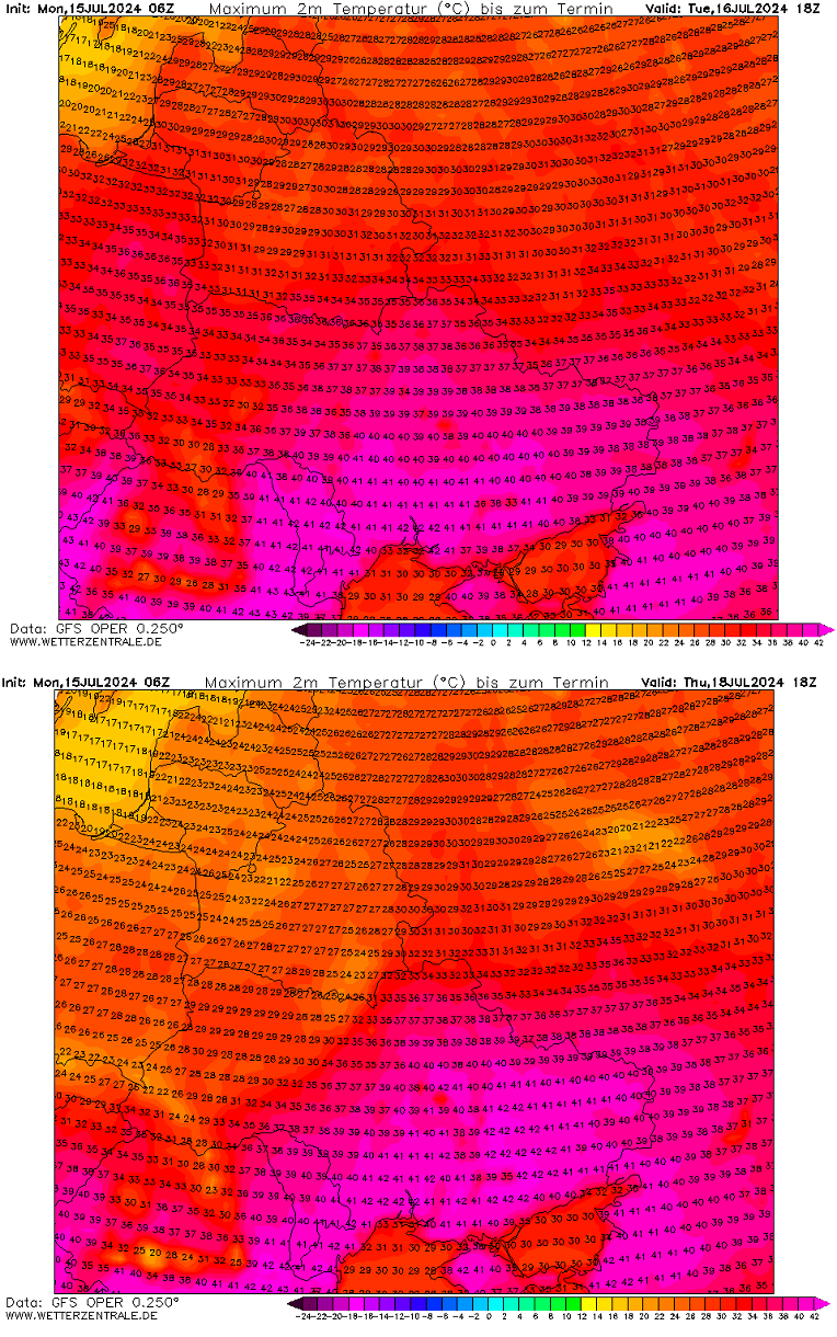
This time, the heat will not expand further north into the Baltic region, so a heatwave is unlikely to develop there.
France, Benelux, and Germany
Once the upper ridge matures and expands north across central and towards western Europe later this week, the heat will also begin to develop on the northern side of the Alps. Temperatures will gradually increase after Thursday, with them approaching the low 30s across France to Benelux and Germany and the low to mid-20s finally for southern England.
While temperatures will not be particularly extreme, they will return to average mid-summer values. The chart below reveals the forecast for peak temperatures from Thursday through Saturday.
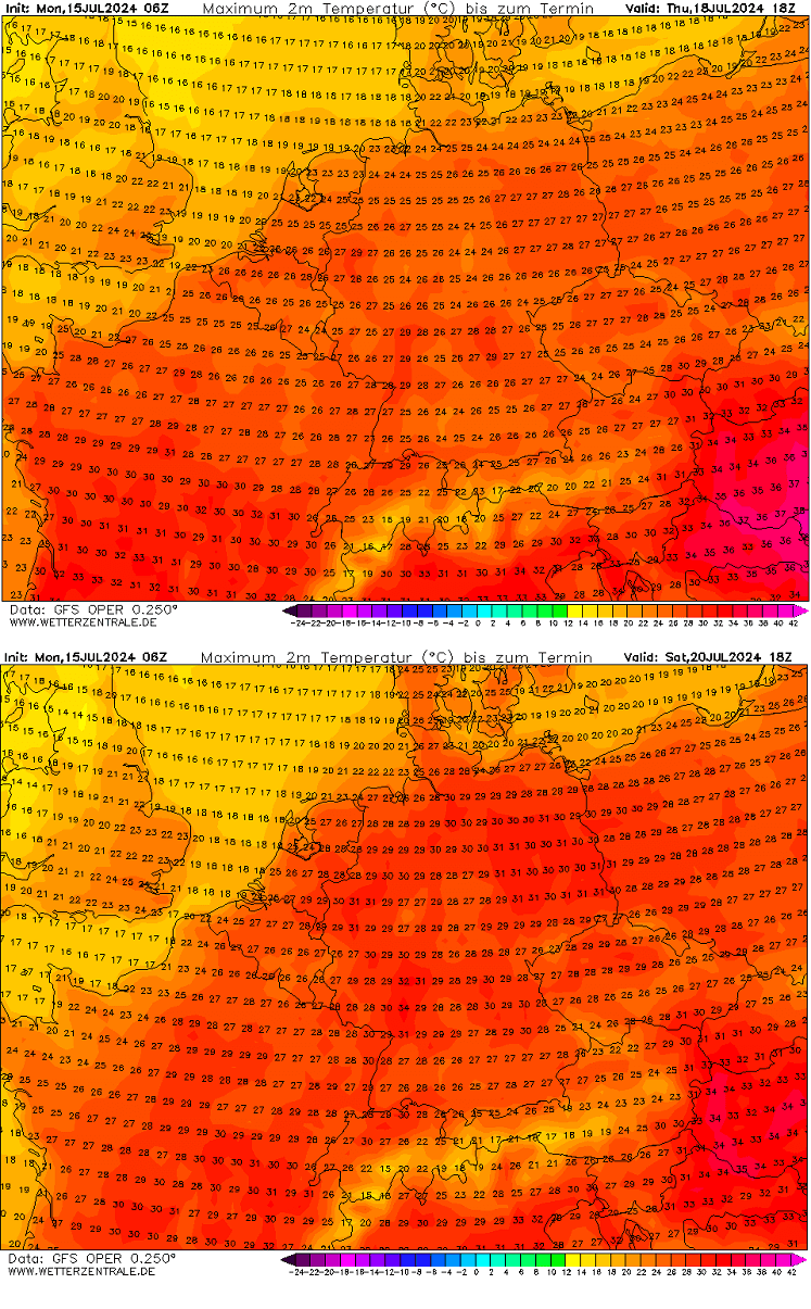
Based on the medium-range forecast models, extreme heat has yet to be forecasted for Western Europe.
Spain and Portugal
The Iberian peninsula has lacked extreme heat this year compared to the last two years. This is thanks to the upper ridges, which mainly developed further east this summer. However, with the expansion of the heat dome later this week further north and west, scorching heat is also expected to occur in Portugal and Spain.
Thursday and Friday’s temperature forecasts call for extreme heat, with peaks into the low 40s across central Spain and southern Portugal. Higher temperatures, likely around 44-46 °C, are forecast for the heat-prone regions across south Spain.
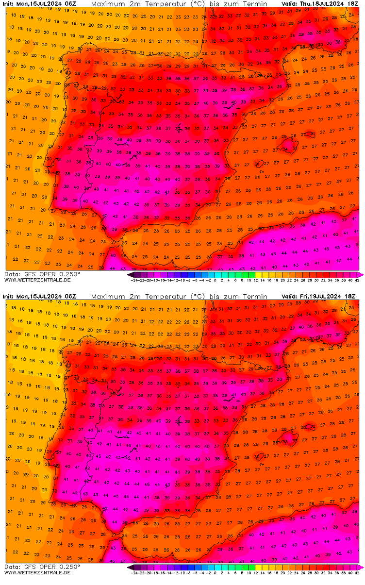
However, the most extreme heat will only last for a couple of days as temperatures are forecast to be a few degrees lower again over the weekend.
Prolonged heatwave warms up Mediterranean region seas; water temperatures are surpassing 30 °C
The persistent and prolonged global high temperatures have also increased sea levels across much of the Mediterranean region. Recently, extreme marine heatwave conditions have been observed, and as heatwaves across southern Europe continue, sea temperatures are forecast to rise even higher.
Parts of the Tyrrhenian Sea, most of the Adriatic Sea, the Ionian Sea, and the Aegean Sea are experiencing high water temperatures this month. Reaching 28-30 °C could challenge some record values in the coming weeks.
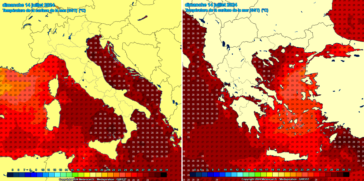
These conditions could become of more significant concern later this summer, especially in autumn. The reason behind these concerns is the amount of potential moisture available for severe thunderstorms in August.
Note that the higher the humidity, the higher the instability and, therefore, the more intense the storms.
August typically has the worst weeks when abundant amounts of rain are associated with frontal systems and combined with extreme instability. At the beginning of August last year, such events occurred in Italy, Austria, and Slovenia, with historic flash flooding events.

Then, during the autumn, the high moisture, still hot air mass, and Mediterranean sea temperatures typically lead to excessive rainfall, multi-day events, and significant floods across the Mediterranean region.
These conditions definitely need to be monitored further, as water heat content from the Mediterranean region has been abnormally high this summer.
Furthermore, if proper conditions are met, the likelihood of Medicanes (Tropical Like Cyclones—TLC) could increase. We will have more updates on the Mediterranean marine heatwaves in the following weeks.
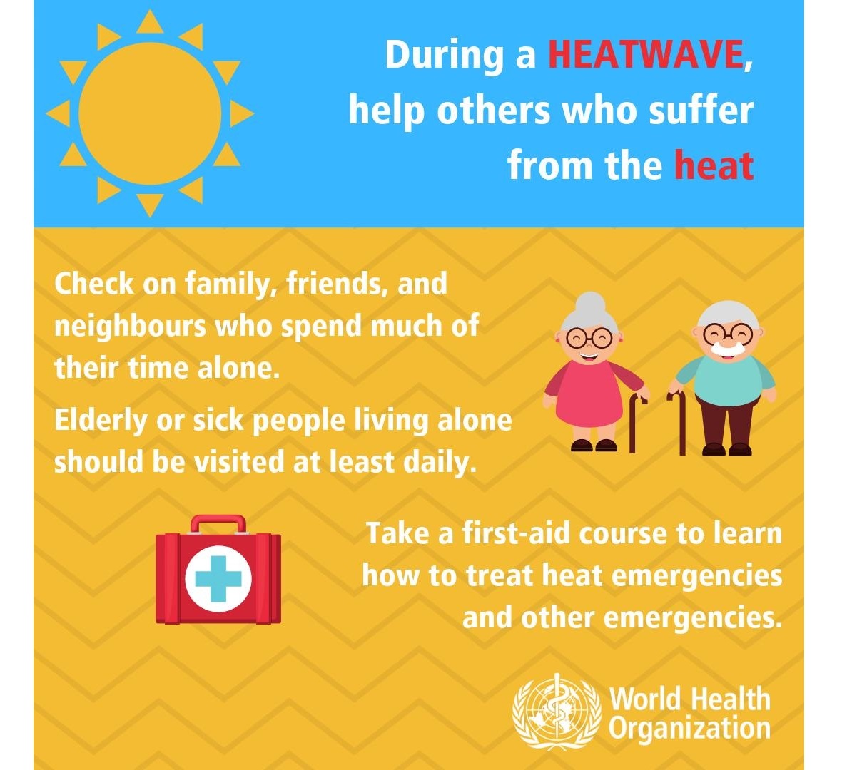
The Health Risks During A Heatwave
During an extended period of hot weather, generally surpassing +35 °C, it is physically challenging and presents an enhanced risk for health.
Sweltering weather, particularly in extended periods – heat waves – is uncomfortable but presents a significant health risk.
Who is most at risk?
Scorching hot weather is uncomfortable for most people. The following groups are particularly threatened by the very high temperatures we encounter during heat waves:
- elderly people aged over 75 years
- babies, young children
- people with chronic/long-term health conditions, such as diabetes, respiratory disease, circulatory disease
- People who are obese
- People taking certain medicines
- people who work outdoors, in hot/poorly ventilated areas, or engage in physical activity in hot weather
- socially isolated people
- people who are not acclimatized to hot weather, such as tourists from northern countries
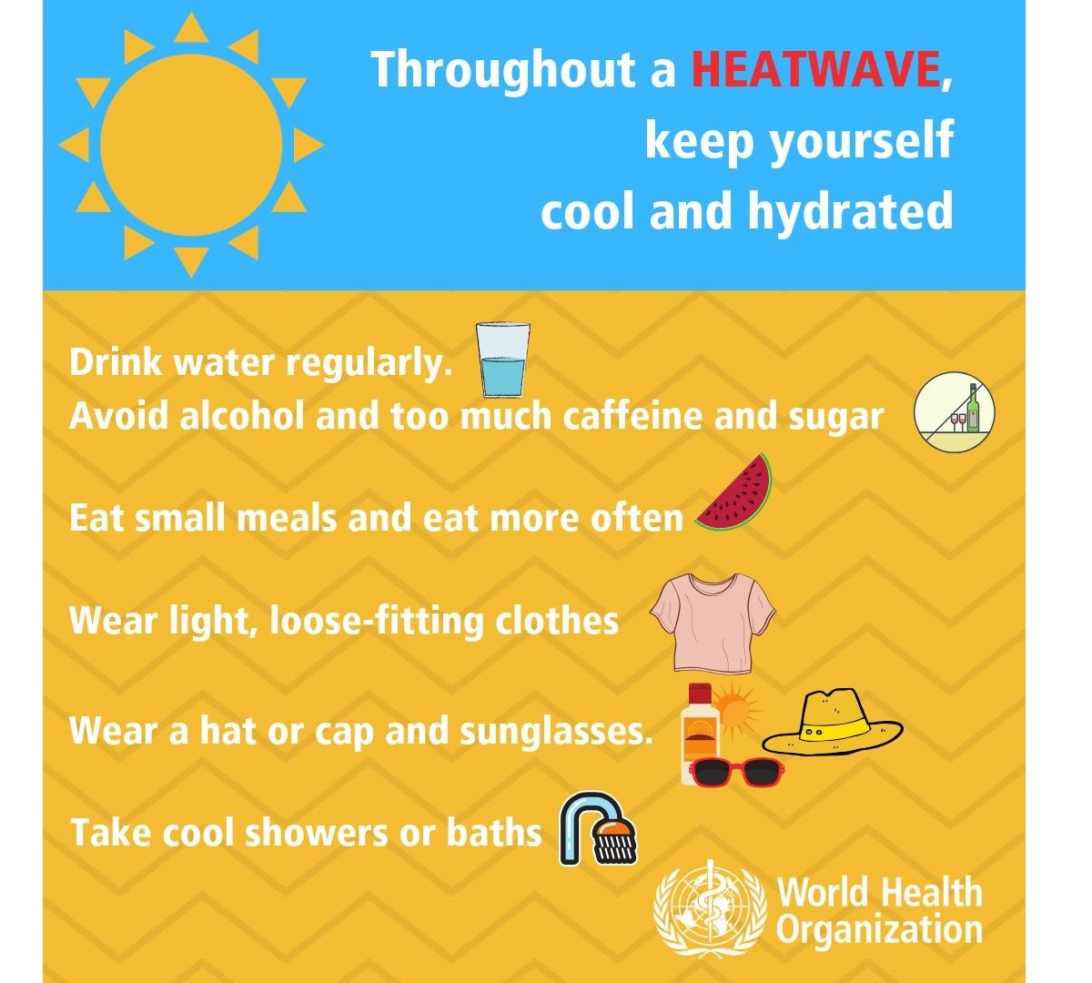
Always stay cool, hydrated, and healthy in scorching hot weather
Staying hydrated is one of the most crucial things during extreme heat. Consider taking these precautions and measures to stay healthy in scorching weather:
- Drink plenty of water! – A human’s body cools through sweating; on a sweltering day, an adult may lose up to several liters of water. Keep drinking water, and avoid drinking alcohol, hot drinks, and drinks with high sugar content, as they can worsen dehydration. Regular water intake is a good way of preventing dehydration.
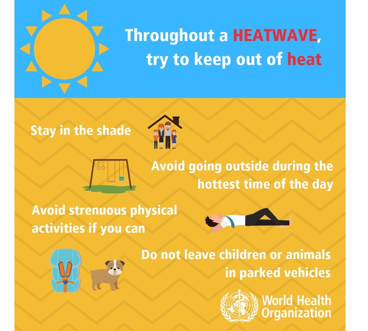
- Keep your body cool; stay out of the sun if possible. Eat small meals, preferably fruit and salads. Wear light-colored and loose clothing made from natural materials like cotton. Take a cool shower or a cold bath if you feel hot. Also – keep your workspace and living space cool. If you do not have air conditioning, shut the curtains and blinds during the day. Stay in the coolest room, and avoid using the stove and oven as much as possible. If your home gets too hot, go to a cooler place – a library, shopping center, cinema, or swimming pool.
- Keep your food safe! Properly Store food that needs refrigeration! Food spoils rapidly at high temperatures, and you may risk food poisoning if it is not stored correctly.
- If you need to go out in the sun, protect your skin, use proper sunscreen and clothing to avoid sunburns, and cover your head correctly.
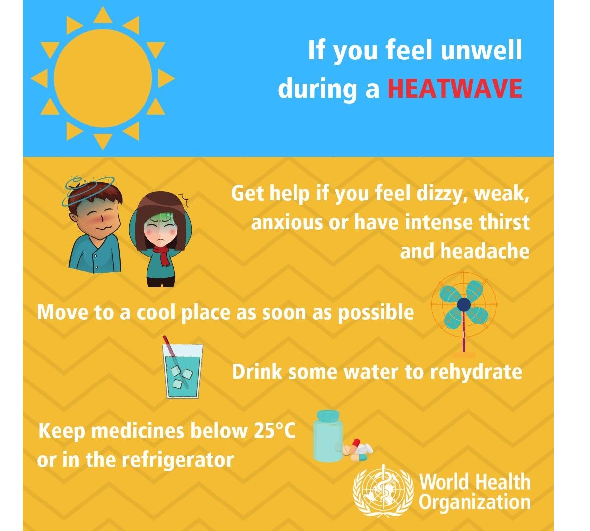
- Know your body and have a plan – Ask your doctor if you have any health conditions that may increase the risk of heat-related illness. Call and consult with your doctor if you are feeling unwell. Call emergency help (know the number!) if you feel unwell!
Common heat-related illnesses with symptoms: What to do if it happens?
WHO considers these symptoms’ descriptions and treatments below as informative only – consult with your doctor for details and professional advice:
Dehydration
Dehydration occurs when the body loses too much water to maintain normal functions. Symptoms include dizziness, tiredness, irritability, thirst, dark yellow urine, loss of appetite, and fainting. Drink plenty of water or diluted fruit juice. Avoid coffee, alcohol, and sugary drinks. Move to a cooler space to cool off. If you feel unwell, call your doctor or emergency room.
Heat rash
Heat rash is an itchy rash caused by excessive sweating. Move to a cooler, dryer environment, and keep the affected areas dry. Hydrating creams may make the condition worse. Consult with your doctor.
Heat cramps
This happens during strenuous activity when the body sweats and loses water and salt. Heat cramps manifest as muscle pains or spasms. If this happens, stop all activity, move/lie down in a cool place, and raise your legs slightly. Drink water or diluted juice. Have a cool shower or bath, and apply ice packs. Refrain from returning to strenuous activity for several hours. If heat cramps do not subside, seek medical help.
Heat exhaustion
Heat exhaustion is a condition caused by dehydration, which causes excessive loss of water and salt. Symptoms include heavy sweating, pale skin, fast and weak pulse, fast and shallow breathing, muscle weakness or cramps, tiredness and weakness, dizziness, headache, nausea or vomiting, and fainting.
If heat exhaustion occurs, the body needs to be cooled and rehydrated by moving to a chilled place, lying down, having a cool shower or bath, and placing cool packs under the armpits, groin, or back of the neck. Rehydration should be done by taking small amounts of cool fluids. Medical help is advised if symptoms do not abate within an hour.
Heat stroke
Heat stroke happens when the body temperature reaches 40.5 °C, a severe and life-threatening condition! Immediate first aid in lowering body temperature is critical, and an immediate call for an ambulance! Find more information on heatstroke here.
High relative humidity during a heatwave can also significantly affect the body, making it physically challenging for those working outside. After high rainfall, intense heating helps evaporate the soaked grounds, resulting in higher humidity than usual.
We use a heat index to represent the natural feel of scorching hot temperatures and high humidity. These graphics indicate the natural feel of temperatures based on the temperature and humidity.
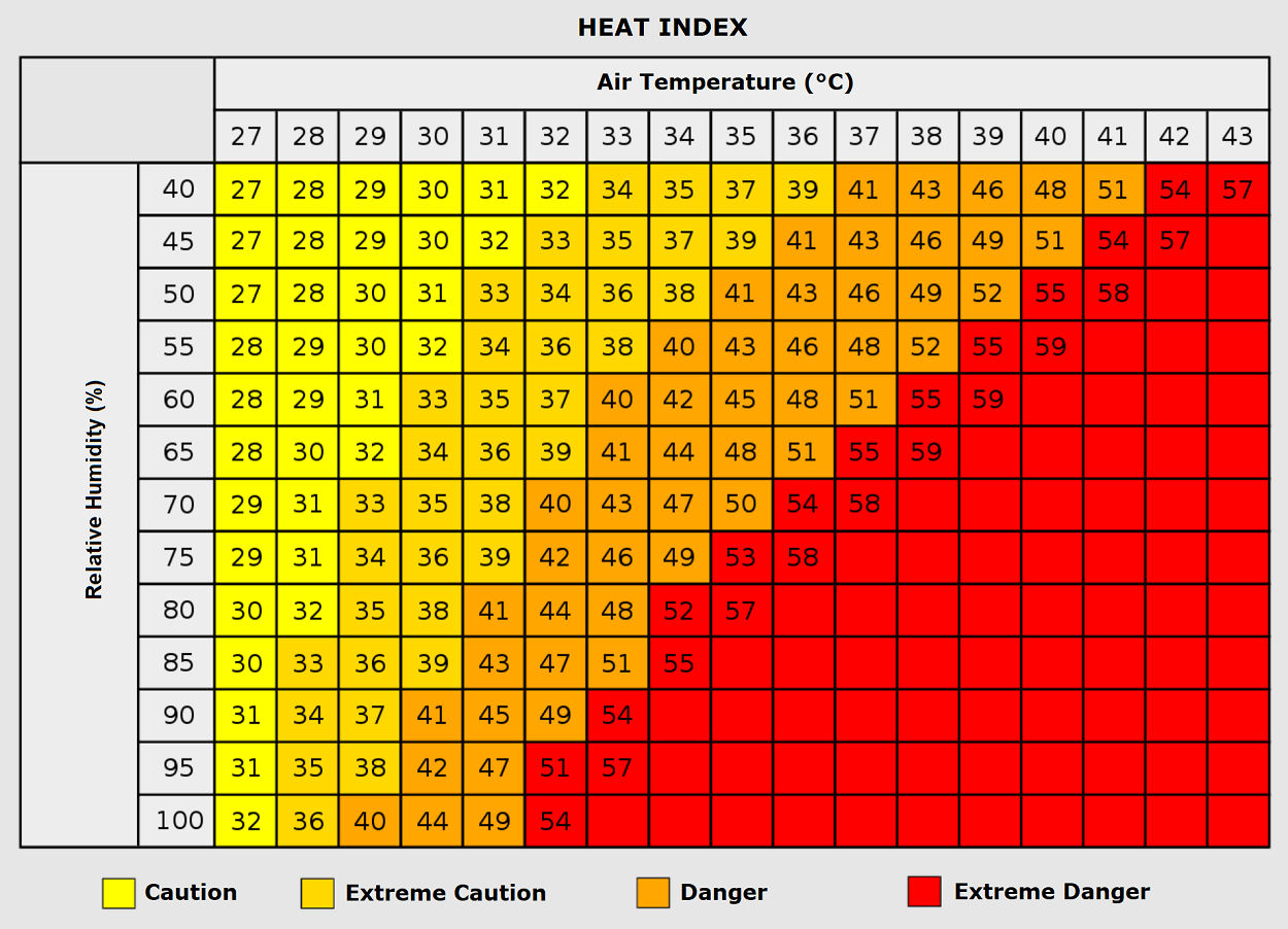
As we see, when air mass has a temperature around +35 °C, humidity below 60 percent is much less challenging than once the humidity is very high, e.g., above 80 %. Thus, the actual feel temperature would be near 50 degrees Celsius.
Even at temperatures close to the 40s, such sweltering hot air becomes hard to handle with even lower humidity, 50 to 60 percent.
Wxcharts, Pivotalweather, ClimateBook, and Meteociel provided images for this article.
See also: