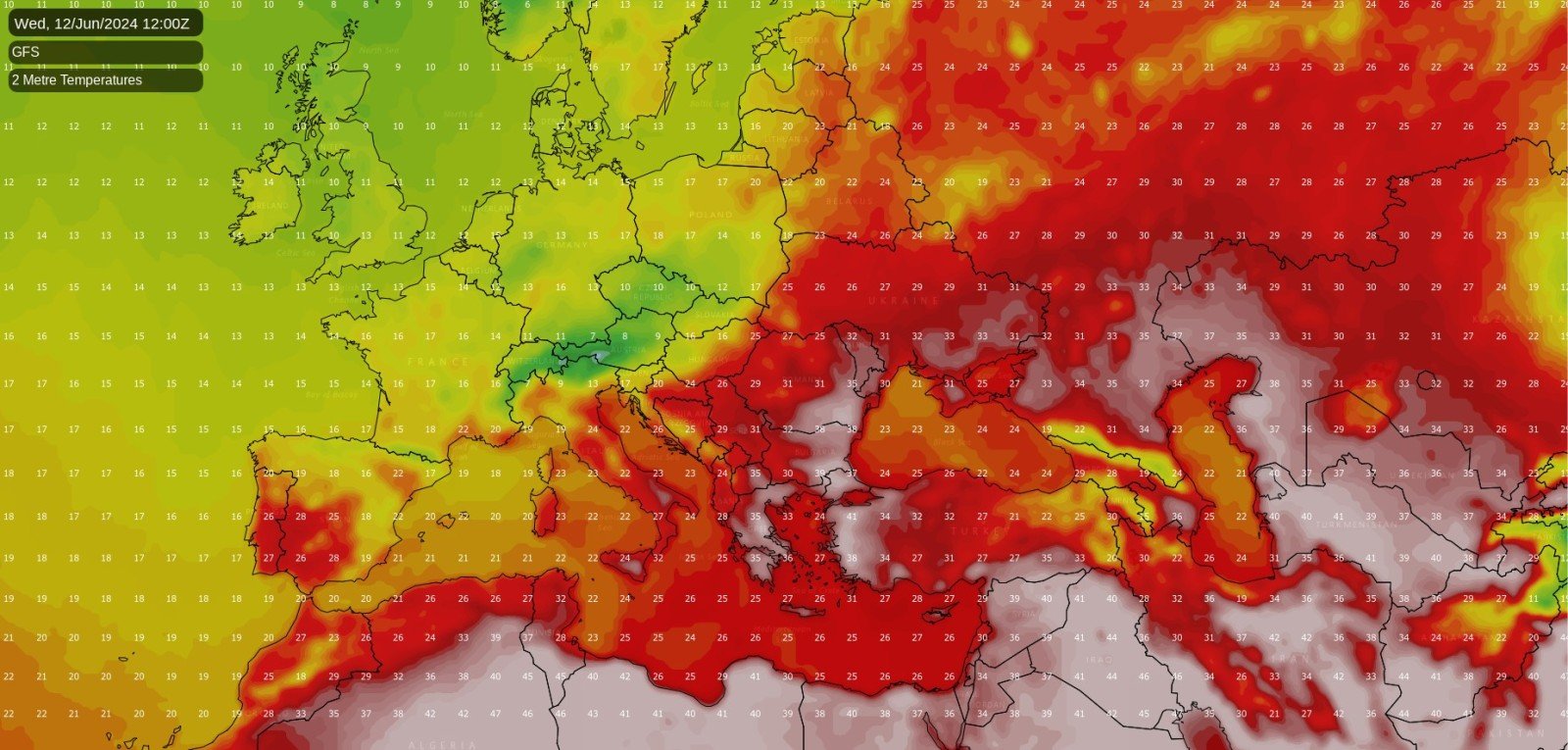
Britain is currently experiencing a cool north-westerly pattern, and temperatures in June have been below the long-term average, contrasting with earlier in the year. Summer heat has largely been concentrated over North Africa, extending into parts of southern Europe. Early in June, Spain and Portugal experienced unusual heat for this time of year, with those high temperatures transferring eastwards and reaching up to 39°C in Greece.
In the coming week and towards next weekend, heat is forecast to intensify over much of northern Africa, with temperatures widely reaching the low to mid-40s Celsius. Some of this heat is expected to move into south-eastern Europe, particularly affecting Italy, Greece, and the Balkans. There is some uncertainty regarding the extent to which the heat will establish in south-eastern Europe, as the GFS and ECMWF forecast models suggest that the heat will probably peak next weekend and into early the following week – which is over a week away. However, there are indications that this region has a substantial chance of reaching the early 40s Celsius away from the coasts. While these temperatures are not unusual in July and August for these regions, they are atypical for early to mid-June. Parts of eastern Europe may also experience this heat.
However, central, northern, or western Europe are not likely to experience notably hot weather in the foreseeable future. A cool, showery, but not especially wet north-westerly pattern looks set to persist until the middle of next week. Afterwards, it is expected to turn more unsettled in north-west Europe with low-pressure systems moving in from the North Atlantic and becoming slow-moving, helping to confine the intense heat to south-eastern Europe.
What This Means for Britain’s Weather
In Britain, a mixed weekend is expected. A weakening band of cloud and rain will move south-eastwards through England and Wales for the rest of today, followed by brighter, showery weather, especially in Scotland and Northern Ireland. On Sunday, another band of cloud and rain, with the rain tending to fizzle out as it moves south-eastwards, will spread through the country, with some dry sunny weather to the south and brighter showery weather to the north. From Monday to Wednesday, the frontal systems are expected to stop coming in, resulting in a slackening north to north-westerly flow with a mix of sunshine and showers, the showers heaviest and most frequent in the east and north-east, and plenty of dry sunny weather in the west and south.
From Thursday onwards, the weather has the potential to turn wet again, with temperatures probably recovering to close to or slightly above the seasonal average as winds turn south-westerly. The warmth will mainly be felt through high overnight minimum temperatures.
Potential for Change Later On
The most likely time for a pattern change is around 20 June. Weather patterns often change in late June, typically associated with a strengthening of the Azores High and increased westerlies heading into north-west Europe. This pattern explains why north-western Britain is often sunniest during May and early June and sees a decrease in average sunshine hours in late June, July, and August when westerlies tend to become more frequent. However, in some years, the jet stream ends up displaced further north, and high pressure ridges over the British Isles. This occurred during the hot summers of 1976, 1995, and 2018, when the first two-thirds of June were dry but relatively cloudy, and then high pressure built after 20 June, bringing hot and sunny weather during the last third of June, which recurred in July and/or August.
There is also a middle ground where we can get a mix of westerlies and high-pressure ridges during the back end of June. In some years, such as 2023, this pattern shift doesn’t occur until July. In 2023, the pattern shift was in stark contrast to 1976, 1995, and 2018, with June 2023 being the warmest and fourth sunniest June on record for the UK, followed by a very wet July with dull and wet weather coinciding with weekends.
It looks likely that southern parts of the UK have a substantial chance of experiencing warm/hot dry sunny weather during the last third of June, with signs of a strengthening Azores High potentially throwing up ridges into southern parts of Britain in particular. However, for northern Britain, there is a greater chance of a predominantly changeable westerly pattern becoming established. A pattern shift in late June would likely lead to some relaxation of the heat over south-eastern Europe while increasing the likelihood of hot weather at times in central and western Europe.
Until around the 20th of June, it is probable that north-western Europe will stay unsettled with temperatures generally no higher than average for the time of year, and the upcoming five or six days are likely to be mostly cooler than average for the UK.

