

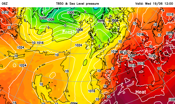
Very warm air is pushing up from Africa through mainland Europe and meeting fresher air from the North Atlantic. Along this frontal boundary are warnings for severe thunderstorms today in France and Germany with the risk of frequent lightning, hail and intense rainfall being highlighted. Many countries across Europe use the same traffic light system of yellow amber red warnings for severe weather. Visitors to the UK can access the Met .Office information, although all the text is in English.
European weather services often include English or several different language options online which is very helpful for tourists. If you are heading off abroad this summer it might be worth becoming familiar with the national met. service websites and radar to just keep abreast of advice about heavy rainfall, thunderstorms and intense heat. Meteo Alarm is a good site which combines all the European weather warnings for today and tomorrow in one place. If you click on a specific area it takes you to the national provider.
The UK also has a thunderstorm warning but this is not such a lively setup. There is an overall northerly flow for the UK but some backing of the wind through the Irish Sea to a northwesterly. Along North Sea coasts as the land warms up in the strong June sunshine, the breeze will veer to an easterly. With convergence inland and the surface heating, convection begins, the Cumulus clouds appear and there is the potential for heavy showers and even in-situ thunderstorms.
“Heavy showers and thunderstorms may lead to some disruption to travel.” Met Office
Within the yellow area there is a risk, the potential for a storm. The ingredients are present and the area covers A1/M1, A19, A66, A65, M66 and includes York, Leeds, Sheffield and Manchester today. This area has been highlighted to have “a medium likelihood and a low impact.”
Low impacts from the Met Office impact guide for Thunderstorms in the UK include-
‘Some flooding of homes, businesses and susceptible roads lasting several hours in places. Some damage to buildings/ structures from flooding and/or lightning. Some transport routes and travel services affected. Some journeys require longer travel times. Road conditions affected by spray and standing water and/or hail. Short-term disruption to power and/or other utilities and services in some places.’
In other countries the impact levels could be different and certainly the severe thunderstorms that mainland Europe can experience in the height of summer can be very dangerous.
With light winds over northern England today, if any storms do appear, they will be slow-moving, increasing the rainfall totals in one location. As always with showers, other places miss out and hold onto more sunshine. The UKV model shows heavy showers from the Solway Firth across to the Humber this afternoon edging southwards into the Peak District and Midlands this evening. You might see the anvil tops of Cumulonimbus clouds.
 Thermal contrast over Europe, heat in the far south and southeast
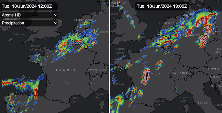
Meteo France has Yellow and Amber warnings for thunderstorms today. The pulse over northeast France for lunchtime won’t now trouble Kent, the rain stays over northern France where it will be very wet with the risk of flooding. There is a wide thunderstorm/lightning risk across France with the southwest, including Bordeaux, seeing the amber level later on Tuesday which mentions large hail risk and high wind gusts, which could cause damage in the region. Rather than just individual thunderstorms, there could be MCSs forming, Mesoscale Convective Systems which carry on into the night, edging east/NE.
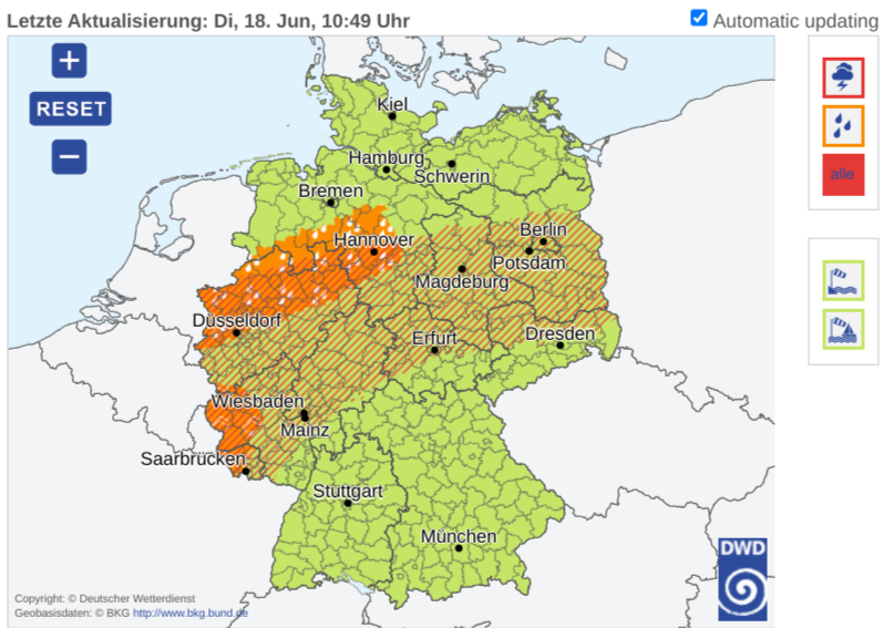
DWD has warnings for severe Thunderstorm risk today over Germany along the same weather front.
‘From Tuesday afternoon there will be severe thunderstorms with (extreme) storm potential starting from both the southwest and the low mountain ranges. Supercells can form, which are accompanied by severe squalls, sometimes hurricane gusts between 90 and 120 km/h (56-75mph) and larger hail between 3 and 5 cm. Heavy rain…Isolated tornadoes cannot be ruled out, especially in the west.’
There are also Amber warnings for Heavy Rain with dangers from ‘isolated, rapid flooding of streets/underpasses and Aquaplaning.’
Northern Spain has rain and thunderstorm warnings, Belgium has rain and flooding warnings and also Poland. The southern heat builds midweek with amber and red high temperature warnings for the Balkans and Hungary on Wednesday.