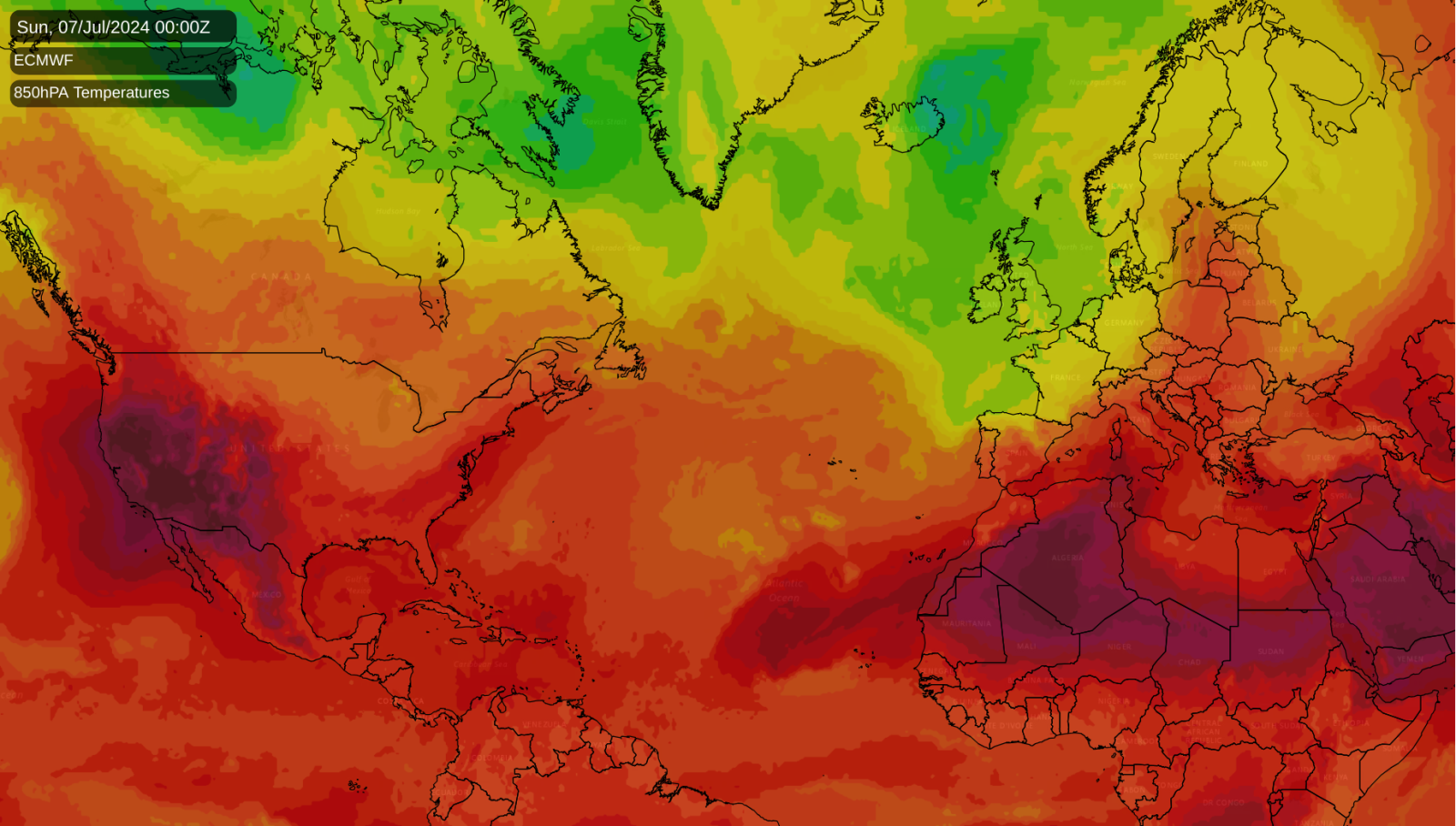
At the end of June, there was considerable support among the medium-range weather forecast models that a “heat dome” was set to develop over the western United States during the first week of July. They have proved to be correct, with a major heatwave having started on 4 July (American Independence Day, as well as the day of the UK national elections).
The heatwave has so far especially been affecting the heavily populated state of California, with over 100 million Americans living under extreme heat advisories. The San Francisco area, which is often relatively insulated from high summer temperatures, has been especially affected. The heat has been spreading up the western side of North America, affecting Oregon and Washington states for example. In Phoenix, Arizona, temperatures have been forecast to exceed 40°C and are expected to reach around 46°C.
The hot and dry conditions have helped wildfires to develop widely, again especially in California, where a wet winter resulted in extensive grass growth, and frequent hot and dry weather in spring and summer have provided conditions that are ripe for the decaying grass to catch fire. The region has suffered heavily from wildfires in recent summers, and there are indications that this July and August could be an especially active season for wildfires.
Pressure patterns are looking stable across the United States during the coming week, so it looks probable that this extreme heatwave in the western USA will persist for the foreseeable future, extending at times into south-western Canada, which has also been affected by some record-breaking heatwaves in recent years. Central and eastern parts of the USA will generally see more moderate temperatures, although the north-east is forecast to be somewhat warmer than average for a time early next week.
European outlook for the coming week
This weekend is forecast to have sunshine and showers for most of Britain, with showers merging into longer spells of rain at times, and potential for some thunder in places, especially today. It has not been a particularly thundery summer so far: most areas were rather cool and dry overall during June, despite a hot spell towards the end of the month, and for most areas the hot spell did not end with a thundery breakdown. Thus, a potentially thundery weekend will rather buck the recent trend.
Central parts of Europe have had some exceptionally heavy and frequent rain in recent weeks, lying on the boundary between generally hot weather in south-eastern Europe and generally cool weather in north-western Europe. This is looking set to continue over the weekend, and although it will become drier in this region early next week, towards the end of the week it is forecast to become wet again, with showers and thunderstorms and sometimes longer spells of rain, particularly around the Alps.
For Britain, the jet stream will be running to the south of its most usual position, sending low pressure systems eastwards across the south in particular, bringing some heavy and persistent rain at times, and potentially some thunderstorms, especially around the English Channel. As has often been the case in recent months, with the jet stream running south, the sunniest and driest weather will quite often be found in north-west Scotland. The shift in weather patterns will result in a brief hot plume spreading through central and eastern France and into central Europe through Tuesday and Wednesday, but this looks set to be short-lived.
For the longer term
There is quite strong support on the medium-range forecast models for high pressure breaking off from the main Azores anticyclone and moving over to parts of Europe starting next weekend and into the early part of next week. There is a lot of uncertainty over where the high will end up. Some forecast runs have the high ridging into central Europe which would leave Britain with a northwest-southeast split in the weather, predominantly warm dry sunny weather for the south-east but cloudier and cooler weather further north and west. Other runs, however, have the high covering the British Isles, which would give most of the country a spell of warm, potentially hot, and sunny weather. Thus, there is relatively high confidence that in 8 to 10 days’ time, the weather will turn warmer, drier and sunnier in south-eastern Britain thanks to this high pressure moving in, but confidence in this pattern change producing predominantly dry and sunny weather is lower the further north and west you are.

